


Tertiary sourceArtifact2007-12
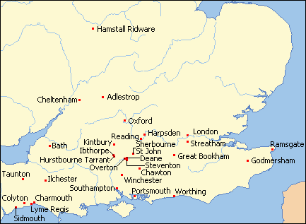
Map of Places Jane Austen Lived or Visited
Ruhrfisch · 2007-12
A modern map marking thirty places in southern England connected to Jane Austen's life, including Bath, Winchester, and Chawton.
A map tracing the places across England connected to Jane Austen's life, helping situate her story geographically.
About this source
What it is
This is a modern map of southern England, created in 2007, marking thirty places where Jane Austen lived or visited during her lifetime. It was made from an online map creation tool and adapted by Ruhrfisch, with red dots showing locations such as Bath, Winchester, Southampton, Lyme Regis, and London.
Why it matters
This map helps students see the geography of Austen's life and understand the places that shaped her experiences and may have influenced the settings of her novels. It is a modern teaching tool, not a historical document from her own time.
Look closer
- What pattern do you notice in the places marked—are they clustered in one region or spread widely?
- How might the places Austen visited have influenced the settings or characters in her novels?
- Why is it useful to see a person's life mapped out geographically?
This artifact is part of the curated material that grounds the AI version of Jane Austen on Humy.ai — when students ask about related events, the AI can quote it and cite it.
More Jane Austen sources
Meet the AI Jane Austen →

Ready when you are
Start chatting with Jane Austen now.
20 messages free · No credit card · Available in 50+ languages.