


Tertiary sourceDocument1 May 2012
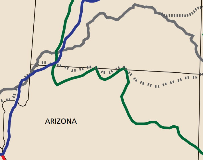
Old Spanish Trail Early Exploration Routes Map
U.S. National Park Service · 1 May 2012
A detailed National Park Service map of southern Utah and northern Arizona showing the 1776-1777 Domínguez-Escalante route in green alongside later trails.
Shows the 1776-1777 route of Escalante's expedition in relation to later trails through the same region.
About this source
What it is
This is a detail map made by the U.S. National Park Service in 2012, focused on southern Utah and northern Arizona, showing the Domínguez-Escalante route of 1776-1777 in green alongside later routes used by explorers such as Jedediah Smith.
Why it matters
The map shows how closely later trails followed or branched from the path Escalante and Domínguez took in 1776. It is a modern tool for understanding how exploration routes developed over decades, built from the earlier journey these two friars made.
Look closer
- Why might later explorers have followed a similar path to the one Escalante took?
- What geographic features might have shaped where these routes could go?
- What is missing from a map like this that a written journal might show instead?
This document is part of the curated material that grounds the AI version of Silvestre Vélez de Escalante and Francisco Atanasio Domínguez on Humy.ai — when students ask about related events, the AI can quote it and cite it.
More Silvestre Vélez de Escalante sources
Browse all 11 → Diary entry
Primary source
Diary of Francisco Garcés on the Anza Expeditions
Francisco Garcés · 1774–1776
Secondary source
History of Utah, Chapter 1: Discoveries of the Spaniards
1889
 Document
Primary source
Este Mapa comprende todas las villas y lugares de españoles
Joseph de Haro · c. 1770
 Artifact
Secondary source
Anasazi Heritage Center
1988
Free account
Read every Silvestre Vélez de Escalante source
Sign up free →
Ready when you are
Start chatting with Silvestre Vélez de Escalante now.
20 messages free · No credit card · Available in 50+ languages.