


Tertiary sourceDocument
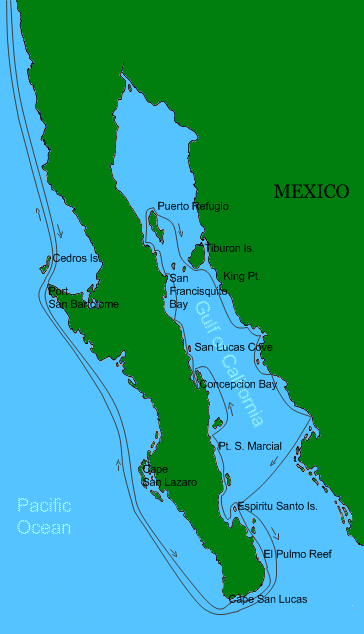
Steinbeck Route Around the Gulf of California
Yomangani
A modern reconstructed map tracing the 1940 route Steinbeck and Ed Ricketts took around the Gulf of California, as described in The Log from the Sea of Cortez.
Traces the 1940 voyage Steinbeck took with Ed Ricketts that became the basis of his book The Log from the Sea of Cortez.
About this source
What it is
This is a modern map created to show the route that John Steinbeck and his friend the marine biologist Ed Ricketts traveled around the Gulf of California aboard the boat the Western Flyer in 1940. The journey was later recorded in Steinbeck's book The Log from the Sea of Cortez. This map is a later reconstruction made for reference, not an original document from the voyage.
Why it matters
The expedition combined Steinbeck's writing with Ricketts's scientific fieldwork, and it shaped Steinbeck's later nonfiction. Maps like this help readers follow the real geography behind a book describing a specific journey.
Look closer
- Why might it help a reader to see the actual route described in a travel narrative on a map?
- What is the difference between this modern reconstruction and a map made during the actual 1940 voyage?
- What questions would you want to ask about how accurate this route reconstruction is?
This document is part of the curated material that grounds the AI version of John Steinbeck on Humy.ai — when students ask about related events, the AI can quote it and cite it.
More John Steinbeck sources
Meet the AI John Steinbeck →

Ready when you are
Start chatting with John Steinbeck now.
20 messages free · No credit card · Available in 50+ languages.