


Secondary sourceDocument
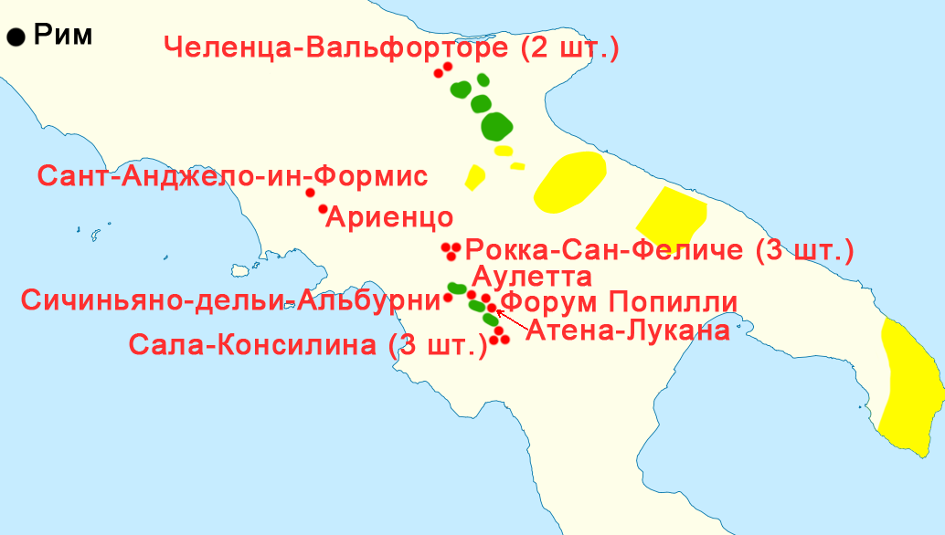
Termini Gracchani Map
Homoatrox, after Botev
A modern map plotting the find-sites of boundary stones set up by Tiberius Gracchus's land commission across southern Italy.
Shows the geographic reach of Tiberius Gracchus's land reform law through surviving boundary stones.
About this source
What it is
This is a modern map, created by Homoatrox based on an original by Botev, showing where ancient boundary stones called termini Gracchani (or cippi Gracchani) have been found. These stones were set up by the land commission established under the law passed by Tiberius Sempronius Gracchus in 133 BC. Red dots mark the stone findspots, while green and yellow areas show land distributed by the commission, based on later scholarly research.
Why it matters
The map helps show the physical reach of Tiberius's agrarian reform law, which aimed to redistribute public land to poorer citizens. It demonstrates that his political program was not just a matter of Roman politics, but had a real, lasting footprint across the Italian countryside.
Look closer
- What does the spread of boundary stones suggest about how far-reaching Tiberius's reform was?
- Why might historians rely on physical evidence like boundary stones instead of just written accounts?
- What is not shown on this map that might still be important to understanding the reform?
This document is part of the curated material that grounds the AI version of Tiberius Gracchus on Humy.ai — when students ask about related events, the AI can quote it and cite it.
More Tiberius Gracchus sources
Browse all 50 →



Ready when you are
Start chatting with Tiberius Gracchus now.
20 messages free · No credit card · Available in 50+ languages.