


Tertiary sourceDocument2010-12-25
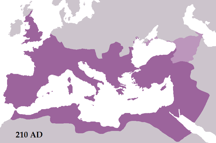
The Roman Empire in 210 AD
Tataryn77 · 2010-12-25
A modern map showing the Roman Empire in 210 AD, after the conquests of Septimius Severus, with Roman territory and dependencies marked in different purples.
A modern map of the empire at Severus's death, showing the territory linked to his campaigns.
About this source
What it is
This is a modern map made by a Wikimedia Commons user, Tataryn77, and uploaded in 2010. It shows the Roman Empire in 210 AD, the year before Severus died. Roman territory is dark purple, and dependencies such as the Bosporan Kingdom and the lands of Armenia, Colchis, Iberia and Albania are in lighter purple. The map is not a historic source and is labelled as a modern reconstruction.
Why it matters
The map shows the territory the empire held when Severus died, after campaigns that the Commons description links to his reign. It covers Britain, Gaul, Iberia, Italy, the Balkans, Anatolia, the Levant and North Africa. It helps students see the scale of the empire he governed, though it cannot show the details of how the borders were set or held.
Look closer
- Which regions does the map show as Roman territory, and which as dependencies? What is the difference?
- Why might a modern mapmaker show borders as clear lines when ancient frontiers were often unclear?
- What does the map leave out, such as people, roads or the campaigns themselves?
This document is part of the curated material that grounds the AI version of Septimius Severus on Humy.ai — when students ask about related events, the AI can quote it and cite it.
More Septimius Severus sources
Browse all 85 →
Ready when you are
Start chatting with Septimius Severus now.
20 messages free · No credit card · Available in 50+ languages.