


Secondary sourceDocument1868
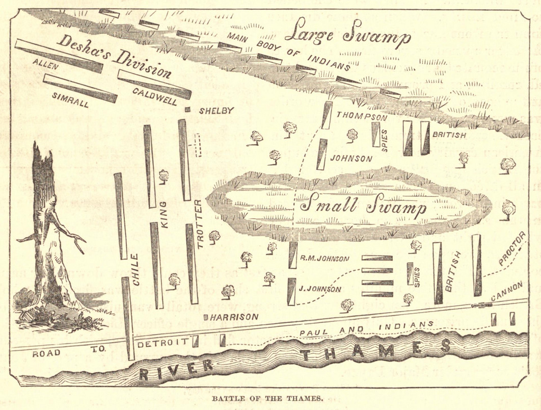
Map of the Battle of the Thames (Lossing, 1868)
Benson Lossing · 1868
An engraved 1868 map of the Battle of the Thames from Benson Lossing's Pictorial Field-Book of the War of 1812, showing American and British units and Native forces.
A later map of the battle where Tecumseh died, showing where his forces were placed in relation to American and British units.
About this source
What it is
This is an engraved map titled 'Battle of the Thames', published in 1868 in Benson Lossing's Pictorial Field-Book of the War of 1812. It shows the River Thames along the bottom, a road to Detroit, and two swamps labelled Large Swamp and Small Swamp. American units such as Desha's Division, Allen, Simrall, Caldwell, Shelby, Trotter, King, Chile, Harrison and Johnson are marked as rectangular bars, with British lines also shown, and the main body of Indians and a group labelled Paul and Indians are marked near the swamps.
Why it matters
The map was made in 1868, more than fifty years after the battle in which Tecumseh died in October 1813. It is a secondary source that was drawn from the records and memories available to Lossing. Maps like this helped readers understand the positions of units during the fight and shaped how the battle was remembered. Tecumseh's forces are marked as the main body of Indians, which is a useful starting point for asking where Native fighters appear in written records.
Look closer
- Where are the Native forces placed on the map compared with the American and British units?
- What does a map show clearly, and what does it leave out about what the fighting was like?
- Why might a historian in 1868 choose to publish a detailed map of this battle?
This document is part of the curated material that grounds the AI version of Tecumseh on Humy.ai — when students ask about related events, the AI can quote it and cite it.
More Tecumseh sources
Meet the AI Tecumseh → Painting
Secondary source
Portrait of Tecumseh
Pierre Le Dru (original sketch); reworked by Benson Lossing, 1868 · 1868 (after an earlier sketch)
 Document
Primary source
Treaty of Greenville
3 August 1795
 Document
Primary source
Messages and Letters of William Henry Harrison
William Henry Harrison; ed. Logan Esarey · 1800-1816 (published 1922)
 Document
Primary source
Northwest Ordinance
Confederation Congress · 13 July 1787
 Document
Primary source
Treaty of Paris
3 September 1783
Ready when you are
Start chatting with Tecumseh now.
20 messages free · No credit card · Available in 50+ languages.